OK, we have lived here nearly thirty years and we have never taken the Mountain Loop Highway. Oft touted as one of the great things to do in this county. To be clear, in our defense for missing this wonderland - there have been several years when the road was closed because of sinkholes and landslides. It always closes for snow. We have gone as far as Barlow Pass and the Monte Cristo trailhead, but there the road turns to dust and we have turned around in the past. Yesterday was the day.
We started with a stop to get a National Forest Day pass at a gas station in Granite Falls then a stop at the Verlot Ranger Station to ascertain that the road was indeed open this year. It was.
We reminised as we drove along about the first camping trip we took in this area. Red Bridge in June. We got rained out and I didn't sleep worrying about Nathan crawling of the edge of the campground into the river. This is where Mike found a freezing snowmelt filled side channel irresistable. Camping in the rain with a crawling child was not great - that trip slowed our camping aspirations down considerably for quite a few years.

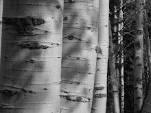
We remembered the hikes up the Lake Twenty-two trail, the Heather Lake trail, Mt. Pilchuck. Tales of scout camps at Wiley Creek and Coal Lake were called to mind. David remembered a backpacking trip to Monte Cristo with Katie. But we stopped at Perry Creek. Three years ago we did this hike with Nathan - we got rained out that day and thought we would do it again. The next five pictures come from that hike.
This Landslide pretty much closed the trailhead. This first group of pictures is from the hike in July of 2008


Because there were tree limbs down (in 2008) we were able to see this Lobaria (the lettuce like plant), a tree top dweller that as it gets knocked out of the trees by the wind supplies the better part of soil nitrogen in the wet forests of the Northwest.

Mosses and Big Leaf Maples like and help each other. The maple trees will actually send out root fibers into the mosses growing on their branches and trunks.

We missed the May lily in the woods behind us this year, they have been closed to the public.

The Northwest always has moss along the trail.
The Mt. Dickerman parking lot is the new trail head and adds a mile to the trail. It was a good trail to take on a busy weekend. It is not as popular as the trails that end at lakes. It was a quiet hike. We didn't make it to the falls because we wanted to do the whole loop road, but we enjoyed the new part of the trail and a small part of the old trail. We saw a few plants we have never seen before - one of them a small flowered orchid.


DER counting the rings - about two hundred for this cedar before it fell. The nice clean cut was because it fell across the trail. This tree would have been a seedling when Lewis and Clark came west.

We love seeing the Canadian Dogwood along the trail.

Can you guess what this is?
The much touted loop, well was mostly a dusty tree lined forest road, but it did have a few really beautiful pull-outs along the Sauk River.


Most of them were not much beyond Barlow Pass. There were many small primitive campsites along the river. They would probably be really nice sometime other than a holiday weekend.